|
|
|||
|
St
Helen's Well (The Wishing Well) - Walton The site of St Helen's well is located alongside the
Rudgate, an ancient trackway, (probably prehistoric in origin) which
crossed the river Wharfe at a place called St Helen's ford near the village of Newton Kyme. On the
north side of the river, the track is called St Helen's lane and passes
through Chapel Wood, where, in the 1530's John Leland (the Tudor
historian) noted a wayside
chapel dedicated to St Helen. A spring in the wood was also dedicated to
this saint and was much visited for its healing properties, the people
often leaving strips of cloth or rags tied to nearby bushes and trees -
a tradition which has not entirely died out (see footnote). Writing around the same time, Harry Speight (3) noted
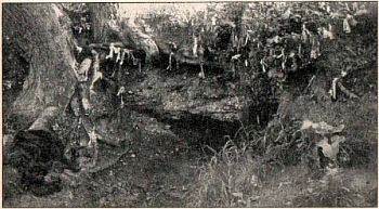
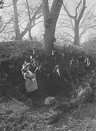
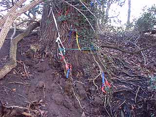
....... . Speight's mention of two other revered springs in the wood could explain the differences between the old photographs shown on this page, which appear to be two different wells sites. Neither picture seems to show any obvious signs of water flowing from the wells and in another book, Bogg noted there was scarcely any water to be seen at the well. Its is interesting to note that even with the lack of water, the tradition of leaving strips of clothes at the site continued. The modern OS map only marks "St Helen's Well (site of )" and several years ago i was told that the site had been destroyed when a large factory was built. However a visit to the area showed that Chapel Wood still existed even though the land around it has been developed as part of Thorpe Arch trading estate. The wood itself seemed relatively undisturbed, and on its east side it was possible to trace the ditch and bank described by Bogg. This ditch appears to be the course of a dried up stream, which at one time ran along the eastern edge of Chapel Wood, with the St Helens spring flowing into it. On the southern edge of the wood the buried remains of a small stone bridge were noted and this would have originally crossed the stream. Unfortunately on this visit it was not possible to use the photographs to definitely identify the site of the well and there were no obvious water sources to be seen. At a later date the opportunity arose to study a first edition (1850) OS map of this area and this map marked the actual position of the St Helen's well. The map also showed the small bridge over the stream, and with this information a return visit was made to Chapel Wood. From the position of the bridge it was possible to estimate the site of the well to within a few metres and this location resembled that shown in the old photograph at the top of this page. but today the actual spring site must lie buried by soil on the slope of the bank. This might have been due to natural soil creep down the banking or more likely when the old tree above the well toppled over. If this is the case then it would be possible to clear the soil and restore the site to something like the picture/ On the visit to Chapel wood in January 2000 it was also noted that an old tree stump had been decorated with different coloured ribbons (see pic 3) and it would appear that this stump has been identified as the remains of the tree shown in the 1907 photo (pic 2 and possibly the 1934 photo shown in the Bord's Holy wells book?). This site is actually a little further north into the wood than the St Helen's well site marked on the 1850's OS map and again this probably relates to Speight's comment about their been two other 'sacred' springs in the wood. All this might suggest that the 'official' St Helen's well near the stone bridge (and nearer the chapel?) may have dried up in the late 1800's, and the focus moved to another still active spring a little further up stream. The old OS map shows a gravel pit alongside the wood and very near the well, so extracting the gravel may have cut off the supply of water to the spring. (1) Edmund Bogg, Lower Wharfedale 1904. remains of st helen's chapel to thorpe arch church? check
|
|
||